SPINA VERDE PARK
Lake Como

Spina Verde Park is a protected forest which covers an area of more than 1000 hectares (approx. 4 square miles). The park is located southwest of Como, and also includes the municipalities of San Fermo della Battaglia and Colverde.

The Spina Verde Park gathers many sites of panoramic, historical, and natural interest. The perfect place to escape the hottest hours of summer and enjoy the spectacle of nature throughout the year.

❗ In this post I take you on a discovery of the western part of the Spina Verde by proposing a route (divided into parts) that starts from Piazza San Rocco, on the edge of downtown Como.

A break in nature, discovering local history and traditional dishes at one of the area’s huts. The route I propose consists of 15-30 minute sections and is suitable for moderately trained people. The huts, however, are accessible and reachable by car.

Learn all about the Spina Verde Park and follow my own steps with the GPS routes I recorded on the Komoot app (available for iOS and Android)!

Useful tips

🎒 Things to bring with you
  • Power bank
  • A cape or poncho to cover yourself in case of rain, a hat for the sun
  • Comfortable hiking shoes
  • Energy snacks such as dried fruit and nuts
  • Water (at least ½ liter)
  • Sunscreen
  • The Komoot app!
🚨 In case of emergency

Call 112 for any kind of emergency

Things to bring with you
  • Power bank
  • A cape or poncho to cover yourself in case of rain, a hat for the sun
  • Comfortable hiking shoes
  • Energy snacks such as dried fruit and nuts 
  • Water (at least ½ liter)
  • Sunscreen
  • The Komoot app!
In case of emergency

1. Spina Verde – West | From Como to Baradello hill

A walk of about 30 minutes from the edges of downtown Como to the top of Baradello hill, on which stands the castle of the same name and from which there is a splendid view of the city. The walk is slightly uphill the whole way.

✨ Highlights

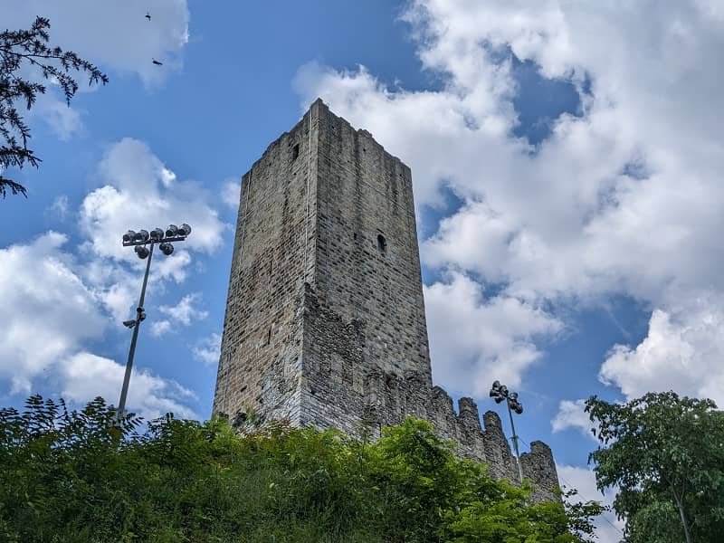
Castello Baradello, the symbol of Spina Verde Park, is a fortification erected in 1558 by Holy Roman Emperor Frederick Barbarossa, on the remains of 6th-century Byzantine buildings.

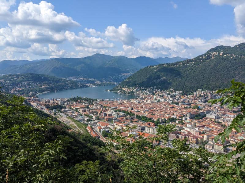
The castle was dismantled in 1526 by Spanish invaders to prevent the French from conquering it, so only a few vestiges remain of the entire complex. The most important are the imposing tower, visible at a great distance in the first basin of Lake Como, and a portion of the defensive walls.

❗ Visits to the tower of Castello Baradello are possible by reservation only: discover the legends about the castle and enjoy the impressive view from its terrace with my friends at Slow Lake Como! They offer a 3-hour tour that will give you exclusive access to the castle and can also include an aperitivo with wine and local productsFind out about it here!

📍 Facilities
Bars and restaurants

At the beginning of the route, in the area of Piazza San Rocco, you can find bars and several restaurants (mostly ethnic). However, if you continue the trail through the woods for about another 30 minutes, you will arrive at Baita Pianvalle hut (remember to check opening hours and, especially on weekends, to reserve a table in advance).

Pharmacies
Grocery stores

In the area between Piazza San Rocco and Via Milano are some grocery stores and mini-markets.

🥾 Trail description

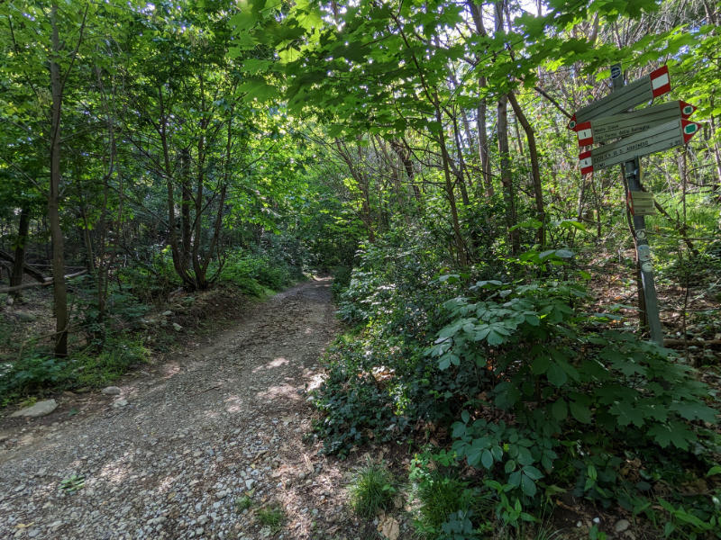
From Piazza San Rocco, where the church of the same name is located, take Via Teresa Rimoldi.

After about a 5-minute walk, at the fork where you will find the Spina Verde Park signs with directions to the castle, turn right onto Via Castel Baradello.

Continue along the paved road, which then becomes a wooded path, and staying along this route you will come across posters explaining the history of the castle. Turn right in the direction of the castle.

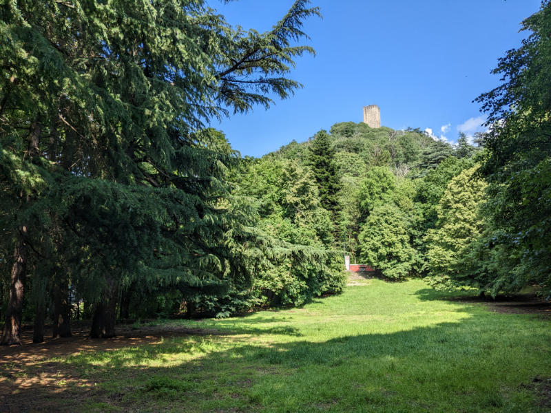
Here is what you will find once you reach the top of Baradello hill:

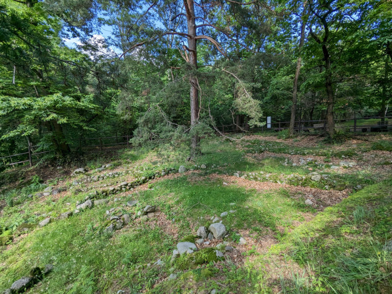
  • Castello Baradello, of which mainly the tower remains, clearly visible from all over the village, and a portion of the defensive walls. Open the "highlights" tab if you want to learn more about its history.
    ❗ The castle is not always open, but it is possible to visit by reservation thanks to my partners at Slow Lake Como.
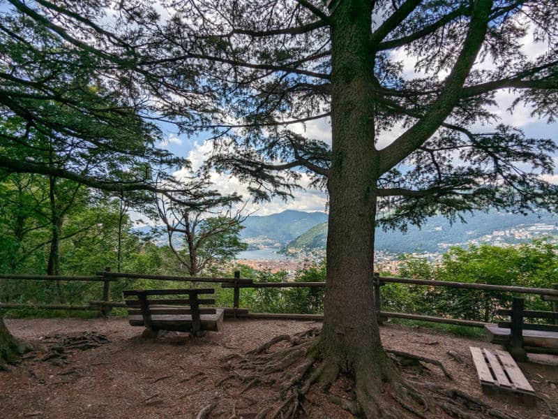
  • A tree-lined meadow where you can rest on wooden seats in the shade of the trees and with a beautiful view of the city of Como.
  • Other vestiges of the ancient complex include a cistern for collecting rainwater and a characteristic watchtower.

From here, you can decide to continue with the second short section of the route or whether to retrace your steps back towards Como.

2. Spina Verde – West | From Baradello hill to Respaù hill

The second section, connecting the top of Baradello hill with the top of Respaù hill, is a short 15-minute walk entirely on a forested trail. It ends upon arrival at one of the viewpoints I am most fond of on the entire lake 💙

✨ Highlights

1. Parco delle Rimembranze, a large meadow with various types of plants and a "bowl" shape that avoids noise pollution.

2. Respaù hill viewpoint, from which there is one of my favorite views of Como and its lake. Once you get to the viewpoint, you will enjoy a 360° view of Como and surrounding areas. On clearer days, you will also have a chance to see the Alps and the skyscrapers of Milan.

📍 Facilities
Bars and restaurants

Baita Pianvalle, at the end of the following section (remember to check the opening hours, especially on weekends, to reserve a table in advance).

Pharmacies

-

Grocery stores

-

🥾 Trail description

From the tree-lined meadow adjacent to the castle, turn back to the signs explaining the history of the castle and take the road in front of you.

Follow the path until, after about 10 minutes, you will find the Parco delle Rimembranze on your right. If you have a snack, you could stop here for a moment and enjoy the rejuvenating effect of nature.

After a short but steep climb the path will pass by the structure that used to house Cascina Respaù, an eco hostel now unfortunately closed.

A few minutes from the end of the trail you will have to leave the main path and take a detour to the right that leads to the Respaù hill viewpoint, in my opinion one of the best in this area of Lake Como.

From here, you can decide to continue with the third short section of the route, perhaps to go for lunch at the end of the next stage, or whether to retrace your steps back towards Como.

3. Spina Verde – West | From Respaù hill to Baita Pianvalle

This short flat section of the trail connects Respaù hill with the junction between Baita Pianvalle and the road leading to the top of Monte Croce, passing by an area that holds remains of the local pre-Roman civilization.

✨ Highlights

The archaeological remains of the pre-Roman settlement found in the Pianvalle area, a short distance from Respaù Hill, testify to the presence of the Golasecca, the first civilization to inhabit the Como area.

In the Protohistoric settlement of Pianvalle, the foundations of juxtaposed dry-stone huts and part of the craft structures used in the Iron Age are still visible.

📍 Facilities
Bars and restaurants

Baita Pianvalle, quaint hut where you can taste some delicious local and traditional Italian dishes. If interested in eating here, remember to check the opening hours, especially on weekends, to reserve a table in advance.

Alternatively, there is also the Baita Monte Croce, located at the top of the mountain of the same name (see following section). Again, it is advisable to call to check opening hours and to make reservations.

Pharmacies
Grocery stores

-

🥾 Trail description

From the viewpoint of Respaù hill, return to the main trail and continue in the direction of San Fermo.

After about a 10-minute walk you will find the archaeological site on the left, which testifies to the presence of the local civilization before the Roman colonization.

Continue another 5 minutes to reach Baita Pianvalle, where you can stop for lunch.

From here, you can decide to continue with the fourth section of the route, perhaps to go for lunch at the end of the next stage (if you haven't already), or whether to retrace your steps back towards Como.

4. Spina Verde – West | From Baita Pianvalle to Monte Croce

Monte Croce

Croce di Sant'Eutichio at Monte Croce

Among locals, Monte Croce is one of the most popular places in all of the Spina Verde Park (you can find a good restaurant here, Baita Monte Croce).

You can get there by continuing along the previous path, or you can start from Via Ronchetto, on the outskirts of Como.

If you arrive from Respaù, you will come across the Baita Pianvalle, another typical inn where you can taste some typical food.

After passing the restaurant, at the point that intersects the road leading up from Via Ronchetto, turn right and continue uphill for about 30 minutes.

Monte Sasso

Springs of Seveso River

Monte Sasso is located in the western part of the Spina Verde Park.

If you love contemporary history, you should go for the trenches and tunnels of the First World War, created to prevent a potential German invasion from Switzerland.

You can get there in approx. 45 minutes by following the road that starts from Via per Bronno, within the municipality of San Fermo della Battaglia.

Before getting there, you will come across the viewpoint of Pin Umbrela, that offers another amazing view of Lake Como

A few minutes away from the trenches, you can also find the springs of Seveso River, which runs for 52 km (32 miles) until it gets to Milan.

The trail starts from the junction near Baita Pianvalle and reaches the summit of Monte Croce, where you can find the viewpoint of the cross of Sant’Eutichio and a hut where you can taste excellent traditional dishes.

✨ Highlights

The cross of Sant'Eutichio, according to tradition, commemorates the place where Eutichio, holy bishop of Como (6th century), retired to pray and do penance, to avert war and famine from the city of Como.

📍 Facilities
Bars and restaurants

Baita Monte Croce, a beautiful hut where you can spend a relaxing day in nature, in an environment ideal for families and children. Only fixed price menus are served and reservations are recommended.

Pharmacies
Grocery stores

-

🥾 Trail description

From the junction located near Baita Pianvalle, take the slightly uphill path leading to the summit of Monte Croce.

Continue, without deviation, on the main path for about a quarter of an hour, until you come across the Baita Monte Croce.

Here there is a small detour that in a couple of minutes leads to the cross of Sant'Eutichio, from which there is a splendid view of the city of Como and the lake.

At this point, after a break in the hut, you can return toward the starting point.

If you want to avoid redoing the whole route, you can also take trail no. 3 from Monte Croce to the Sant'Abbondio area.

Another alternative is to descend back to the junction near Baita Pianvalle, turn right at the fork on via Monte Croce and, crossing the outskirts of Como, reach via Gabriele d'Annunzio where you can catch bus 1 heading to the center of Como.

Experiences & tours

Make your trip a unique experience!​

The tower of Castello Baradello, Como
Exclusive tour of a medieval castle over Como city
Spina Verde Como
Lake Como Rebels: war & smuggling
Como-Brunate-Torno
Como-Brunate-Torno: breathtaking scenery
Val Senagra
Val Senagra:
the enchanted valley
Related posts

Leave a Reply

This site is protected by reCAPTCHA and the Google Privacy Policy and Terms of Service apply.